


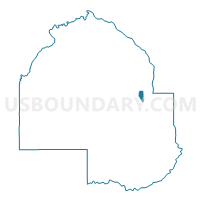
Robbinsdale W-2, Hennepin County, Minnesota
About
Outline

Summary
| Unique Area Identifier | 602438 |
| Name | Robbinsdale W-2 |
| County | Hennepin County |
| State | Minnesota |
| Area (square miles) | 0.93 |
| Land Area (square miles) | 0.80 |
| Water Area (square miles) | 0.13 |
| % of Land Area | 85.98 |
| % of Water Area | 14.02 |
| Latitude of the Internal Point | 45.03025780 |
| Longtitude of the Internal Point | -93.32441960 |
Maps

Graphs
Select a template below for downloading or customizing gragh for Robbinsdale W-2, Hennepin County, Minnesota


Neighbors
Neighoring Voting District (by Name) Neighboring Voting District on the Map
- Brooklyn Center P-6, Hennepin County, MN
- Minneapolis W-4 P-4, Hennepin County, MN
- Minneapolis W-4 P-7, Hennepin County, MN
- Minneapolis W-4 P-8, Hennepin County, MN
- Robbinsdale W-1, Hennepin County, MN
- Robbinsdale W-3, Hennepin County, MN
- Robbinsdale W-4, Hennepin County, MN
Top 10 Neighboring County Subdivision (by Population) Neighboring County Subdivision on the Map
- Minneapolis city, Hennepin County, MN (382,578)
- Brooklyn Center city, Hennepin County, MN (30,104)
- Robbinsdale city, Hennepin County, MN (13,953)
Top 10 Neighboring Place (by Population) Neighboring Place on the Map
Top 10 Neighboring Unified School District (by Population) Neighboring Unified School District on the Map
Top 10 Neighboring State Legislative District Lower Chamber (by Population) Neighboring State Legislative District Lower Chamber on the Map
- State House District 46B, MN (38,019)
- State House District 45B, MN (36,600)
- State House District 58A, MN (32,902)
Top 10 Neighboring State Legislative District Upper Chamber (by Population) Neighboring State Legislative District Upper Chamber on the Map
- State Senate District 46, MN (75,090)
- State Senate District 45, MN (73,414)
- State Senate District 58, MN (70,239)
Top 10 Neighboring 111th Congressional District (by Population) Neighboring 111th Congressional District on the Map
Top 10 Neighboring Census Tract (by Population) Neighboring Census Tract on the Map
- Census Tract 204, Hennepin County, MN (4,637)
- Census Tract 212, Hennepin County, MN (4,500)
- Census Tract 213, Hennepin County, MN (4,428)
- Census Tract 1002, Hennepin County, MN (3,543)
- Census Tract 3, Hennepin County, MN (3,173)
- Census Tract 214, Hennepin County, MN (3,137)
- Census Tract 1007, Hennepin County, MN (3,025)
- Census Tract 1013, Hennepin County, MN (1,604)